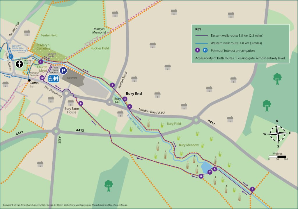
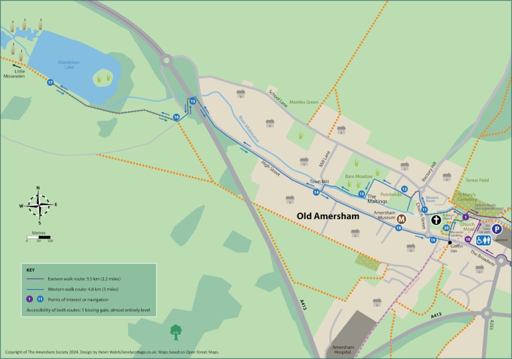
A riverside walk along the Misbourne in and around Amersham starts from Church Mead, just west of the Old Town Car Park (where there are public toilets). The total length of the walk is slightly over 8 km (5 miles) but is conveniently split into two parts:
Eastern Walk
The eastern part is a circular walk, albeit a very squashed circle, going out along the north bank of the river and returning on the opposite bank. If the river is in flood, following prolonged heavy rain, it may be impractical to cross the river at the mid-point, so you may need to return by the same route. To download a printable copy of the route map click on the image below (PDF 3 MB), for directions and additional historical, geological and environmental information please scroll down.
From the Amersham Society’s Church Mead information panel ❶ use the little wooden bridge to cross the river and turn right (east) and follow the path between the cemetery and river. This attractive path quickly narrows and can sometimes be slightly overgrown and muddy (but always passable with care). The car park is on your right and this is where the Roman road and prehistoric trackway must have forded the river.
After 100 m there is a short climb and the path emerges into a field. Follow the path alongside the river. Ignore the bridge to the supermarket and carry on past the small-holding. On your right hand side you will pass a cylindrical concrete structure set into the ground. This was the mounting point for a Spigot Mortar used by the Home Guard during the second World War Continue until you emerge on to Station Road. ❷ Use the pedestrian-controlled traffic lights just to your left to cross this busy road safely, turn right and then almost immediately left down a footpath (Walnut Mews) next to a shop and houses. In 50 m emerge into the car park ❸ of the Chequers Inn on the left and Ambers on the right. The latter is the former Bury Mill and if you crouch low to avoid reflections when looking through the window just to the right of the entrance door you can see the water flowing into the mill building, although sadly the water wheel has now gone.
Turn left for a few metres along the busy main road and cross it carefully when you reach a bus stop, opposite a field gate. (You may find it easier to got right a few metres and cross using the bollards near the roundabout). Once across, head along the footpath next to the river almost opposite The Chequers. ❹ Follow this path through Bury Field alongside the river, first through scrubland, then woodland and under the Amersham by-pass. The path drops steeply until you emerge into the open fields of Bury Meadow.
On the opposite bank of the river, you may be able to glimpse the lake, created a few years ago by Affinity Water to improve the river. These are rapidly becoming favourites for bird-watchers and the surrounding area has increasing displays of wild flowers. Continue along the river bank in this large field for a few hundred metres until you reach a crossing hedge and path. ❺ Turn right and use the simple bridge to cross to the opposite bank of the river but it can be muddy at this point. At times of flood, it may be impractical to cross the river here, so you may need to retrace your seps.
In the distance, over to the left, you may be able to see what was once Quarrendon Mill, now a private house. The South Bucks Way goes past it, but not very closely, and our route turns back towards Amersham.
When you have crossed the river, do NOT follow the farm track half left across a field (which may be flooded even if the bridge is passable) but turn right to walk along the river bank in a large field. Follow the river until you have to turn left to avoid the lake ❻. The lake is fenced off and you may get a better view if you take the opportunity to climb up the bank. ❼ Follow the path when it turns right through a kissing gate ❽. The main track turns left through the gate to follow a hedge until it joins the South Bucks Way, where you turn right along the edge of a large field. (You could instead head straight on across the field until it joins the South Bucks Way but there is no clear path and it is quite hard going across the tussocky grass). The field narrows and path gradually leaves the river. It becomes a farm track and goes under the by-pass, passing the waterworks on the right then past houses and converted farm buildings to emerge through Bury Farm onto the main London Road, opposite the supermarket. ❾ Turn left and then use the drop kerbs to carefully cross this busy road. Once over the road, turn left to cross the entrance to the superstore. Continue along The Broadway towards the Old Town. A few metres beyond the Old Town Car Park entrance, notice the two sarsens set into the pavement, either side of the entrance to the office building. ❿ These were markers for the prehistoric trackway, although doubtless were once further up the hill. Go into the Old Town Car Park, keeping to the left, until you reach the river, where you turn left to soon return to your starting point. ❶
Length of the eastern route is 3.5 km (2.2 miles), 1 kissing gate, almost entirely on the level but after rain may be flooded just beyond ❺
More information about what you will see en route is below:
Quarrendon Mill
The place-name Quarrendon is believed to derive from the Old English words cweorn, meaning mill (related to modern English quern and possibly corn) and dūn, which means hill so it is tempting to think there was once a mill on a hill near here. Tempting, but unlikely: if it was on a hill it would be a windmill but why build a technically difficult windmill when there was a good river for a water mill? The village of Quarrendon is almost 20 miles away, north of Aylesbury. The current mill takes its name from Quarrendon Farm, ½ mile north-west up the side of the valley but perhaps the farm was once owned by somebody from the village.
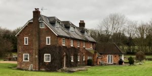
Quarrendon Mill was a new corn mill built by William Holding on land leased from William Drake in 1766. In 1798, Joseph Impey was producing 48 sacks of flour per week. The mill burnt down in 1855 but was rebuilt and in 1883 was advertised at an annual rent of £60. It was no longer in use by 1936, perhaps 25 years earlier than that. The remaining machinery was removed in about 1940 and it is now used as a private house.
Water was fed to the mill by a leat, a diversion of the river Misbourne. It was brick-lined and last used in about 1930. The original construction of the leat straightened the river channel and moved it away from the valley bottom.
As part of long-term plan for the whole of the River Misbourne, in 2020 Affinity Water carried out carried out an improvement project on a 1 km stretch on Bury Meadow and adjacent land, from the Amersham by-pass to Quarrendon Mill, going through pasture land and further downstream arable fields. This whole section of river was artificial, with the original natural channel some 60 – 70 m to the south-west. Because it was away from the valley bottom, there was little ground water re-charge so the river was prone to drying out at times of low flow. Conversely, during times of high flow (or blocked channels), water would spill out and run across the fields to the bottom of the valley, re-joining the river via the remnant channel to the south of the mill.
River improvements: Amersham to Quarrendon Mill
The work Affinity Water carried out was aiming to return the river to the bottom of the valley close to its original course, making it more resilient to low-flows and reducing the risk of flooding. As part of the project, a wetland area was also created to provide a feature for local wildlife to thrive, as well as additional flood storage capacity in the winter months. An earth bund was constructed to prevent any potential increase in downstream flood risk. In addition, gravel berms were installed in the channel to create a more meandering form, resulting in a variation in flow and habitat more typically seen in chalk streams. Fencing along the river bank helps prevent livestock trampling the banks and to reduce disturbance of bird species using the wetland area. Sections of the grazing field have been seeded with a wildflower mix which should also encourage biodiversity at the site. It will take some time for aquatic animals and plants to become established at the site and to be reflected in our environmental monitoring results, however a number of bird species have already been using the wetland area, such as the white and yellow wagtail and the ringed plover. Eventually we will expect fish species including brown trout to migrate to the new re- aligned channel and to also spot kingfishers.
Geology of the River Misbourne
Around 100 million years ago the area that would eventually become the Chilterns was submerged under a clear, sub-tropical sea. Soft, white limestone was slowly laid down under this sea as the remains of millions of coccolithophores (microscopic algae) fell to the seabed. Warm seas covered the area for more than 20 million years, and the chalk beds grew thick.
The famous flint of the Chiltern Hills is a type of silica that was also formed during this period. Silica-rich organisms like sponges and diatoms died and fell to the seabed, their silica replacing chalk that had dissolved or been burrowed away. Eventually, flint nodules formed in these gaps.
The same tectonic movements of the Earth’s crust that formed the Alps caused the chalk to buckle and fold, and these sedimentary rocks emerged from the receding sea. Over millions of years, wind and water eroded the soft limestone that was laid down during the age of the dinosaurs, leading to the formation of the steep chalk scarp and shallower dip-slope that can be seen today.
The Earth went into the Quaternary Ice Age around 2.6 million years ago. Throughout this period, there were times when the ice advanced and times when it receded (like now). During these periods sand, gravel and clay were deposited in layers over the Chilterns’ chalk by glaciers, melt waters and wind. For several thousand years, the Chilterns was a tundra and the chalk frozen, making it impermeable to water, and allowing surface water to erode the rock and create the chalk stream valleys. This ended with the Pleistocene glaciation. Meltwater rushed south over semi-frozen chalk hills, carving out the distinctive chalk downland found in the Chilterns. When the glaciers finally retreated about 10,000 years ago, the open grassland of a frigid and chilly post- glacial period made way for the early colonisers of pine, dogwood, juniper, then finally the oak, alder and willow of a deciduous and temperate wet woodland.
[Adapted from Chilterns National Landscape and River Misbourne Appraisal]
Variable flows in the Misbourne
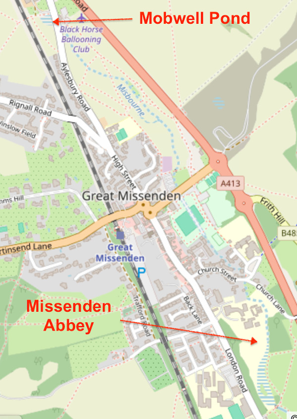
The Misbourne is a winterbourne, ie a river that flows intermittently. Most of the rain falling on the Chilterns sinks into the ground and percolates slowly through the rock to form the saturated zone of the chalk aquifer. It can therefore take some time for groundwater levels to respond to rainfall. If there is plenty of water in the chalk aquifer, typically from December through to April, the river rises at Mobwell Pond, just north of Great Missenden, exceptionally in fields even further north. However, in the autumn the river may not appear until the grounds of Missenden Abbey, south of the village, or in really dry years even further south at Little Missenden. Thus, there is sometimes a flow through Great Missenden and sometimes not. However, there is almost always flow from Little Missenden down the valley towards Amersham.
The Anglian glaciation, some 450 000 years ago was the most extreme during the last two million years. In Britain the ice sheet reached the Isles of Scilly and diverted the ancestral River Thames from its previous course through the Vale of St Albans south to its present position. This heavily eroded and broke up the bedrock between Amersham and Chalfont St. Peter. The chalk underlying this part of the river is lumpy and highly porous unlike the river further upstream at Amersham and beyond, which is rich in clay and much less porous. As a result, the river dries up between Amersham and the Chalfonts. The groundwater levels through the Chalfonts are further below the riverbed level than elsewhere and can vary significantly over time. Although the disappearance of water in the upper reaches of a chalk stream is quite normal, the disappearance in the middle reaches, such as here, is very unusual and the result of the underlying chalk broken up almost half a million years ago.
Western Walk
The western part is partly a there-and-back walk, although the later part of the return route follows the attractive High Street with only limited access to the river behind the houses. To download a printable copy of the route map click on the image below (PDF 3 MB), for directions and additional historical, geological and environmental information please scroll down.
From the Amersham Society’s Church Mead information panel ❶ head west along the path on the south side of the river bank towards the brick bridge. This is said to have Roman foundations, but nothing is visible. Do NOT cross the bridge but instead turn left to follow the riverside path towards the church. Note the date 1634 carved into the key stone where the river emerges from a culvert. It’s not clear whether the carving is contemporary with the building but there certainly was a brewery on this site in 1636. The brewery buildings are now offices, Badminton Court.
When you come to the road (Church Street) turn right. ⓫ This whole area was the centre of the Weller brewery operation. There were offices and stables for the dray horses in Flint Barn Court and several of the houses were used by the Weller family or their senior employees. Cross the road when you have a good view in both directions. In 80 metres turn left onto School Lane. The white building with 3 gables on the corner of Rectory Way was used as the barrel store. Once in School Lane immediately take the footpath heading half left across a green and then left between houses. Carry straight on, ignoring the minor road going right. ⓬ Soon emerge onto Pondwick’s, now a community orchard and haven for wildlife. The ponds (back waters) were deliberately created by Affinity Water in 2023 to reduce the risk of flooding and improve the environment. Almost in the centre, the blue doors on the opposite bank are the Day Alms houses, and over to the left you can see the garden of the Amersham Museum. Most of the bridges are private but at the right hand end the bridge leads to the garden of the Elephant and Castle pub. The buildings at the western end of the meadow are part of the Maltings, built by the Weller’s brewery in 1829, although rebuilt after a disastrous fire in 1837.
After you have enjoyed this tranquil spot, return along the path to the minor road at ⓬ and turn left along it. Keep straight on through a gateway onto Barn Meadow. When the flint walls of the Maltings buildings end turn left, again passing more of the Maltings, until you reach the river, where turn right. ⓭ Follow the river bank, noting the various improvements made by Affinity Water in 2023 and passing the Amersham Society’s Barn Meadow information panel near the paddling area. As at Pondwicks, most of the bridges are private but one leads to the garden of The Eagle pub. At the western end of Barn Meadow follow the narrow path between the river and houses to merge on Mill Lane. The path can be muddy. Town Mill (once Sibley’s Mill) is straight in front of you, although now a private house.
Turn left. Sometimes a small spring, characteristic of a chalk environment, can be seen flowing in the small green on the left and a sarsen can be noted at the top end. At the High Street turn right. ⓮ Cross the road to continue on the footpath, heading west. The river is on your right and you may catch glimpses of it although it’s on private land. Continue on the footpath on the left-hand side of the road for 300 metres. Then the path veers off slightly to the left (opposite Coppas Farm), leaving the High Road and then briefly joining the by-pass. ⓯ It leaves the by-pass after 50 m and descends to the river bank and turns left under a bridge, and then emerges into woodland. Soon you reach a side road, often used as a car park by walkers. Go through the gates into Shardeloes Park ⓰ and turn right onto the road round the cricket field. The Club was founded in the 1870s and has been on the same site ever since. At the pavilion continue in the same direction to cross the field, heading towards a gap just to the left of a wooded area. Follow the footpath (the South Bucks Way) through a short stretch of woodland to a kissing gate into Shardeloes Park. (This can be muddy). In the Park, where there may be animals, please stick to the lakeside and do not wander into the parkland which is private. Stop after about 150 m when first the stable block and then the porticoed front of Shardeloes House emerge from behind trees at the top of the hill. You could continue on this route to the attractive small village (and pubs!) of Little Missenden (where another mill turned into a private house can be spotted). You could return from there via either Toby’s Lane or Beamond End Lane to Mop End and then through woods and fields to join the Shardeloes drive at Lower Park House. But our walk ends here ⓱, by the lake. Then retrace your steps back to the town.
When you reach the turn into Mill Lane ⓮, instead continue along the attractive High Street. All the buildings on the left (north) side back on to the river. You may occasionally glimpse it, or could sit in the riverside gardens of The Eagle or the Elephant and Castle pubs, or the Amersham Museum ⓲, situated in probably the oldest domestic building in the town. John Leland, visiting in about 1539, said the street was well-built with timber. You may feel disappointed at the apparently small number of timber-framed buildings left, but don’t be deceived. The Georgians covered the timber fronts with bricks, but look down the sides of buildings or under archways – the timber frame is still there. Go on past the Market Hall ⓳ into Market Square and then the Broadway. There, near the Griffin Inn, turn left through the Memorial Gardens ⓴, back to Church Mead ❶.
Length of the western route is 4.8 km (3 miles), 1 kissing gate, almost entirely on the level.
More information about what you will see en route is below:
Shardeloes: the Manor and the Mansion
At the time of the Norman Conquest, the parish of Amersham was divided into 6 manors. Shardeloes may have been a sub-manor of one of them but the first known reference occurred in 1308, when part of the Amersham estate owned by Lawrence de Broc was granted to Adam de Shardeloes. A later lease was granted in favour of William Latimer in 1331, and John Latimer received a further grant in 1334. It later passed to Henry Brudenell, and remained with that family until the mid-15th century, when it passed through the marriage of Elizabeth Brudenell to Thomas Cheyne. It then went to Henry Fleetwood in 1590, who lived at the Vache in Chalfont St Giles. In turn, he alienated it to William Tothill in 1595. Joan Tothill, co-heir of William Tothill, married Francis Drake of Esher. He bought the manor and it stayed in the Drake family to the present day. The family acquired other manors so their land holding grew in size over the centuries but death duties resulted in most of the houses they owned in the town being sold in 1928. Most of the land at Shardeloes was sold in the 1950s but the Tyrwhitt-Drakes still retain the freehold of the ground where the cricket club is sited, still where it was founded in the 1870s. The Tyrwhitt-Drakes are still Lords of the Manor, although they no longer reside in Amersham.
There is an 18th century engraving of the Manor House which preceded the present building. It appears to be Tudor in style, with 90 rooms including the servants’ wing. The current mansion was constructed between 1758 and 1766. Stiff Leadbetter of Eton was initially appointed as the architect but when he died Robert Adam replaced him and he was responsible for the large portico on the north side.
During the 2nd World War Shardeloes was requisitioned as a maternity hospital with over 5000 babies being born there during and just after the war, including the lyricist Sir Tim Rice. The Tyrwhitt-Drake family moved to Little Shardeloes (in the High Street) in 1940 and did not return to the Mansion after the war. The latter was sold to a property developer and there were plans to demolish it in 1957 and re-use the bricks to build new houses on the site. The Amersham Society was set up in 1956 with an initial aim of preserving the house. It succeeded and by 1961 the mansion and its service wing had been converted into apartments.
One of the most noted residents in post-war Shardeloes was the film and TV actor Dulcie Gray and her husband, actor Michael Dennison. Following her death in 2011, in her will she left money to the Amersham Society which partly funded the Town Map outside the Memorial Gardens and the Society’s two information panels on Church Mead and Barn Meadow.
Shardeloes: a view of roads and canals
In 1720, Montagu Garrard Drake wanted to dam the River Misbourne in order to increase the size of the lake in his park. He applied to the Quarter Sessions (local courts, replaced in 1972 by Crown courts) to divert the road from Little Missenden to Amersham from the south side of the river to the north side. Parts of the previous road, on the south side, now form the long-distance public footpath known as the South Bucks Way. The ‘new’ road on the north side is now the southern lane of the dual carriageway, created in 1991, although the by-pass was diverted through a cutting so the main road no longer goes past the entrance drive to Shardeloes.
In 1792, plans were drawn up to construct the London and Western Canal, joining the Oxford Canal to London and passing through Thame, Aylesbury, Wendover, the Missendens, Amersham and Uxbridge. In Amersham it would have passed through Shardeloes Park. Unsurprisingly, this was opposed in Parliament by the then Lord of the Manor, William Drake, and others. As a result, what is now the Grand Union Canal, was built through Tring instead.
Shardeloes: a view of railways
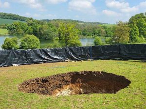
In the 1830s, there were proposals for the London and Birmingham Railway, Britain’s first inter-city route, to follow the Misbourne valley, through the Wendover Gap. Thomas Tyrwhitt-Drake, by now the Lord of the Manor, opposed the route, allegedly because he thought it would spoil the view from Shardeloes. The final route went through Tring and the Watford Gap.
In 1880, the Metropolitan Railway opened their line to Harrow. It was gradually extended and in 1887, Thomas Tyrwhitt-Drake (son of the previous Lord of the Manor with the same name) sold some land on Amersham Common to the railway company. Amersham Station was opened in 1892 and the line to Aylesbury ran along the top of the valley, mostly well-screened from Shardeloes in a cutting.
In 2020, construction of HS2, the high-speed railway from London to Birmingham began. It would follow the Misbourne Valley but a 16 km (10 mile) tunnel was to take it under the Chilterns. There were many concerns about this tunnel damaging the chalk aquifer or even leading to the bottom of Shardeloes Lake being breached. The worst fears were not manifest but several sink holes did open up, including one in 2023 which opened about 100 m south of the lake. It was about 6 m in diameter and 5 m deep. It has now been filled in and nothing can be seen of it.
Shardeloes Park: a landscape park
The entire Shardeloes estate originally comprised two parts. This part, to the north of the mansion, is an 18th-century landscape park and woodland. The other part was the Rough Park to the south, extending to Mop End and Woodrow and incorporating what is now the crematorium and the electricity substation. The whole estate originally comprised 390 hectares (100 acres), although much of it has now been returned to agriculture.
Beech trees were cropped from the estate and used to help pay the death duties in the 1920s. However, mainly it was a sporting estate. There used to be horse races in the field to the south of the long entrance drive, with the whole town turning out to watch. It was a shooting estate, hosting trials for retrievers and cocker spaniels in the early 20th century. The foxhounds for the Old Berkley Hunt were kept at Shardeloes, at Kennel Farm and later at Coldmoreham.
The first landscaping of the grounds of the Shardeloes estate in the seventeenth century was probably designed by Charles Bridgeman (who laid out Hyde Park). It may be him who advised Montague Garrard Drake (1692-1728) on moving the Aylesbury road in order to enlarge the lake. The enlarged lake would then show the house to best advantage to those passing along the new road, as a perfect reflection in the sheet of water. After Montague Garrard’s death his son William Drake senior (1724-96) used Nathaniel Richmond, who had been a foreman of Capability Brown, to design the pleasure ground immediately surrounding the House and may have been responsible for the design of the enlarged lake.
William Drake senior moved to London and made over the estate to his eldest son William Drake junior. In 1792 and 1793 the latter invited the landscape gardener Humphrey Repton to survey the estate. Repton’s conclusion was that the park was already very good, but that he could make it even better by developing a new ride from the house, passing under the turnpike using a picturesque bridge (possibly designed by John Nash), then up the slope and into the woods near Hyde Heath. There, Repton proposed a new pavilion, where the Drake family could take a picnic while enjoying the glorious views back towards the house. The ride would then head east towards the (Old) Rectory before heading back downhill to Shardeloes. Unfortunately, William junior died shortly after Repton had handed over his Red Book, complete with his own water colours, detailing the plans. William junior’s father, William senior, died a year later. The net effect was that William junior’s brother, Thomas, inherited the estate and he was much more interested in hunting than in landscaping so little if any of Repton’s design was executed.
Shardeloes Park: an ornamental lake
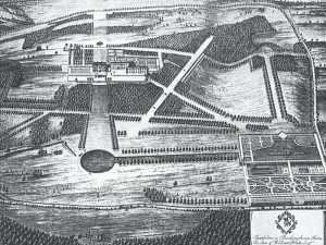
There was a rectangular pond in the late 17th century with a banqueting house and boathouse, before the round pond shown in the illustration below. The ornamental lake is listed in the Register of Parks and Gardens of Special Historic Interest. It is an artificial lake, fed by the chalk stream and feeding the stream.
In a picture dating from 1729, the lake comprised a straight canal and a circular feature but a picture thirty years later shows a much larger lake. In 1753, J. Collins wrote that Roman coins, a pavement and ‘bodies’ had been found when the lake was being enlarged. During World War 2, the lake was drained, the parkland ploughed up, and silt from the lake spread over surrounding land.
An 18th century engraving shows the lake being used for boating and fishing and some early 20th century photographs show ice skating. However, in the winter of 1774, there had been heavy rain which fell onto frozen ground, the dam was washed away causing flooding in Amersham. This may have led to the area of the lake being reduced. The lake was fenced off under the Reservoirs Act 1930 and is now privately owned. The lake is a popular bird-watching site, especially for water fowl.
